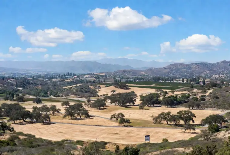
Land in Temecula
Before you build, you buy the dirt. Land in Temecula looks deceptively simple from the side of the road, but Riverside County's mix of city-zoned infill and unincorporated acreage means every parcel carries its own private rulebook. A responsible investigation answers six questions, in order, before you write a check or call a lender. Walk the list top to bottom and you will know whether the parcel in front of you is a home site, a science project, or a trap wearing a nice view.
Every one of those six layers lives in public records, and our free tool pulls them into one clean report in under a minute. Already have an APN or address in hand? Skip ahead to the free parcel lookup, then come back for the full guide.
In This Guide
- Parcel Identity
- Zoning and the General Plan
- Natural Hazard Overlays
- Access, Utilities, and Easements
- Soil, Septic, Wells, and Perc
- Special Tax Districts and Mello-Roos
- Financing Raw Land
- Land-to-Construction Transition
- Wine Country and Agricultural Land
- Using the Free Parcel Lookup
- Frequently Asked Questions
The Six-Layer Parcel Check
- Identity. APN, acreage, legal description, recorded ownership.
- Zoning. The code that governs what you can build, paired with the General Plan designation.
- Hazards. Flood district, fault zone, liquefaction, fire severity.
- Access and utilities. Water, sewer or septic, power, road frontage, easements.
- Special districts. Mello-Roos CFDs, school bonds, HOA or subdivision covenants.
- Financing fit. Which lender actually writes paper on your parcel type.
Parcel Identity: APN, Acreage, and Ownership
Every parcel in Riverside County carries a nine-digit Assessor's Parcel Number, usually printed with two dashes: 921-370-004. That number is the county's fingerprint for your dirt, and it travels with the land through every sale, loan, and permit for as long as the subdivision stays intact. Before you do anything else, grab the APN from the listing or the seller, then confirm it matches the legal description on the preliminary title report. Title reports read like a court docket, but the meaningful lines are the vesting (who owns it), the legal description (where it is, in metes and bounds or lot-and-block form), and the exceptions (what you are not getting).
Acreage on the tax roll is not always acreage on the ground. The assessor rounds, the surveyor measures, and those two numbers can drift by a full tenth of an acre on hillside parcels where the recorded boundary follows an irregular topo line. For anything above one acre, or for any parcel priced on a per-acre basis, a record-of-survey or ALTA survey is money well spent. Ownership chains also matter because inherited parcels often show a deceased owner still on record. Closing on one of those requires a probate or a quiet-title cleanup, and that conversation belongs to an escrow officer, not a lender.
Read every exception in the preliminary title report before removing contingencies. Exceptions are the carve-outs: recorded easements, mineral rights, subordination agreements, covenants, conditions, and restrictions. They are not defects per se, but they restrict what you can do. An access easement across the middle of your only buildable pad is a different parcel than the one you thought you were buying. Ask the title officer to walk you through anything exotic. They do this for a living and they will answer the phone.
Deeper on this: see the Riverside County Parcel Map resource for the direct link into the county's GIS viewer.
Zoning and the General Plan
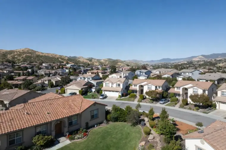
Zoning is the rulebook. The General Plan is the long-term strategy. They are related but not the same, and ignoring either one is how buyers end up with a parcel they cannot build on. Zoning codes in unincorporated Riverside County read like license plates (R-A-5, R-R, W-2, A-2-20), and each one comes with a minimum lot size, allowed uses, setback requirements, and a maximum building footprint. The City of Temecula runs its own zoning map with its own codes, and they do not translate to county codes. A parcel on one side of Rancho California Road might fall under city zoning with municipal water and sewer while the hillside lot across the street answers to the County of Riverside and requires a well permit and septic system.
The General Plan designation is the bigger picture. It describes what the jurisdiction intends the area to become over twenty or thirty years. A parcel zoned R-R (Rural Residential) today but designated "Highway Commercial" in the General Plan could, in theory, be rezoned. In practice, rezoning is slow, expensive, and political. Planning departments are explicit that rezoning is not a speculative exercise.
"One of the reasons we require a project to be submitted within six months is we want to ensure that these aren't just speculative land use changes."
John Hildebrand, Planning Director, Riverside County, as quoted in The Riverside Record
Before you put money down on a parcel hoping to rezone it, read the actual zoning ordinance for your code. Allowed uses are explicit. Conditional uses require a Conditional Use Permit, which can take months and is not guaranteed. Setbacks, height limits, and lot coverage ratios will quietly shrink your buildable envelope below the number you had pictured in your head.
Riverside County zoning code quick reference
| Code | Meaning | Typical use |
|---|---|---|
| R-A | Residential Agricultural | Rural residence with limited agriculture |
| R-A-5 | Residential Agricultural, 5-acre minimum | One home per 5 acres, typical for De Portola |
| R-R | Rural Residential | Low-density rural home sites |
| W-2 | Wine Country Commercial | Commercial winery, tasting room, event venue |
| A-1 | Light Agriculture | Small-scale farms and ranches |
| A-2 | Heavy Agriculture | Intensive agriculture, larger minimum lot sizes |
Simplified reference. The governing codebook is Riverside County Ordinance 348.
Full breakdown: our buying land in Temecula guide.
Natural Hazard Overlays: Flood, Fault, Fire, and Liquefaction
Riverside County land sits on top of real geology. The hazards are well mapped and the mapping is public, which means there is no excuse for getting surprised at closing. Four overlays deserve a hard look on every parcel, and each one has its own cost and construction consequence.
Flood districts. FEMA publishes Flood Insurance Rate Maps (FIRMs) showing Special Flood Hazard Areas. Anything inside a Zone A, AE, or V requires flood insurance if you carry a federally backed mortgage. Temecula Creek, Murrieta Creek, Santa Gertrudis Creek, and their tributaries create pockets of flood zone throughout the valley floor, and rural parcels near seasonal washes often carry the same designation even when they look dry in April. An elevation certificate from a licensed surveyor sets your policy premium and can pull a borderline parcel out of high-risk status entirely.
Alquist-Priolo fault zones. California regulates surface fault rupture through the Alquist-Priolo Earthquake Fault Zoning Act. The Elsinore Fault runs along the west edge of the Temecula Valley, and any parcel within a regulatory Alquist-Priolo zone requires a site-specific geologic investigation before you can pull a permit for a structure for human occupancy. The California Geological Survey is explicit on the rationale: "The intent of the Alquist-Priolo Act is to reduce losses from surface fault rupture." Translate that out of Sacramento-speak and it means a few hundred thousand dollars of mitigation, or no house.
Liquefaction zones. Where loose, saturated soils sit on top of an active fault, shaking can temporarily turn the ground into a slurry. The Seismic Hazards Mapping Act identifies these zones, and building inside one requires an engineered foundation keyed to site-specific soils data. The cost lives inside the foundation drawings, not the house plans.
Fire Hazard Severity Zones. Cal Fire maps areas as Moderate, High, or Very High FHSZ. Much of the hillside acreage west of Interstate 15, along De Portola Road, and up toward Vail Lake falls into High or Very High zones. That designation dictates defensible space, ignition-resistant construction, and, increasingly, your homeowner's insurance premium. Some carriers will not write new policies in Very High FHSZ areas at all, which means the parcel is financeable only if you can find a carrier who will.
| Overlay | Mapping Authority | Cost or Construction Impact |
|---|---|---|
| FEMA Flood Zone (A, AE, V) | FEMA Flood Map Service | Required flood insurance, elevation certificate |
| Alquist-Priolo Fault Zone | California Geological Survey | Site-specific geologic report before permit |
| Liquefaction Zone | California Geological Survey | Engineered foundation, soils investigation |
| Fire Hazard Severity Zone | Cal Fire OSFM | Defensible space, ignition-resistant materials, insurance premium |
Access, Utilities, and Easements
A parcel with no legal access is, in the eyes of most lenders, worth less than a parcel with a gravel driveway. Legal access means an easement or fee-owned road connection to a public right-of-way. Shared driveways, prescriptive easements, and handshake agreements with neighboring landowners are all reasons an appraiser or title company will flag a file. Before you fall in love, verify how you get to the building pad and how that route is documented in the title report.
Utilities are where raw Temecula acreage separates from the planned community lots. Rancho California Water District and Eastern Municipal Water District cover most developed areas, but outlying parcels rely on private wells. Sewer is limited to city service areas and a few county-franchised systems, so most rural parcels require engineered septic. Electric service from SDG&E or Southern California Edison can be stubbed to the property line or sitting half a mile away at someone else's transformer, and that last quarter mile can run thirty to seventy thousand dollars to extend. Natural gas is even rarer outside the city core, which is why so many wine country estates run on propane.
Easements cut both ways. An easement on your title report is something another party is entitled to use on your land: utility corridors, access driveways, water conveyance, view protection. An easement in your favor gives you rights on a neighbor's land. Read every exception in the preliminary title report, map it on the plat, and ask the title officer what each one restricts. Blanket easements across the middle of a parcel can eliminate buildable area you did not know you were losing.
Typical utility extension costs
| Utility | Typical cost to bring to the pad | Notes |
|---|---|---|
| Electric (SDG&E or SCE) | $30,000 to $70,000 per quarter mile | Distance from nearest transformer drives cost |
| Water (district main) | $15,000 to $50,000 | Tap fees plus trenching |
| Private well | $50,000 to $150,000 | Depth, yield, and water quality vary |
| Conventional septic | $15,000 to $40,000 | Requires passing perc test |
| Engineered alternative septic | $40,000 to $90,000 | Mound, sand filter, or drip dispersal |
| Natural gas | Often infeasible in rural areas | Most rural Temecula homes use propane |
Soil, Septic, Wells, and Perc Tests
If your parcel is on septic, a percolation test is the single most important number in your file. The perc test measures how fast water drains through the soil, and the County Environmental Health department uses that number to size the leach field and decide whether a conventional septic system is even feasible. Dense clay, shallow bedrock, and high groundwater can all fail a perc test, and failure means either an engineered alternative system (expensive, sometimes fifty thousand dollars more than conventional) or no permit for a house at all.
Wells tell a similar story. California's Department of Water Resources maintains well logs, and a competent land buyer pulls them for every well within a quarter mile of the parcel to gauge depth, yield in gallons per minute, and water quality. Parts of Temecula wine country sit on decent aquifers. Other hillside parcels drill deep and come up dry, or hit boron and arsenic that require point-of-use treatment. A new well can run fifty to one hundred fifty thousand dollars, and the risk is entirely yours.
Soils reports round out the trio. Before a builder breaks ground, a geotechnical engineer takes core samples and writes a report on bearing capacity, expansive clay content, and slope stability. The foundation design flows from that report. For anything on a hillside, that document is the difference between a slab that cracks in year five and a slab that sits quietly for forty.
Perc test and septic quick reference
What does a perc rate in the 30-to-60 minutes per inch range mean? Good to moderate. A conventional gravity-flow septic system is typically feasible, assuming adequate acreage and soil depth.
What does a perc rate above 120 minutes per inch mean? Poor. You are looking at an engineered alternative system: mound, sand filter, or drip dispersal. Costs climb fast.
What happens if the test fails entirely? In Riverside County you can test again in a different location on the parcel, or the parcel does not support a residence. That is the whole sentence.
When do I run the test? Before close of escrow, inside the inspection contingency period. Sellers are generally responsive to a perc contingency because it is standard practice on unimproved lots.
Special Tax Districts and Mello-Roos
The headline property-tax rate in California is roughly one percent of assessed value under Proposition 13. The real number on a Temecula tax bill is often closer to 1.7 or 1.9 percent, and the difference shows up as Mello-Roos. A Community Facilities District (CFD) is a special tax district that funds local infrastructure (schools, parks, arterials) by assessing properties inside the district a supplemental annual tax for twenty to forty years. Master-planned Temecula neighborhoods like Roripaugh Ranch, Harveston, and Wolf Creek carry significant Mello-Roos. Older Temecula and most unincorporated parcels do not.
For a raw-land buyer, the question is whether the parcel is inside an existing CFD and whether future development would trigger a new one. The Riverside County Assessor and the Tax Collector's Special Assessments look-up are the authoritative sources, and listing remarks are not. School district bonds (Measure J, Measure Y variants) also layer into the bill. Every dollar on the tax bill compounds across your amortization, so the real monthly cost of a parcel is the P&I plus taxes plus insurance, not just the loan payment.
Deeper on this: Mello-Roos in Temecula, explained.
Financing Raw Land
National banks rarely touch vacant land. The lenders who actually write paper on Temecula acreage are agricultural credit associations, regional community banks, and a handful of specialty portfolio lenders. Farm Credit West is the heavyweight for rural Riverside County because it understands wine country collateral and carries decades of local appraisal history. Umpqua Bank writes lot loans and short-term bridge products for buyers planning a build. Community banks and credit unions occasionally do relationship deals on acreage when the borrower has an existing banking relationship.
Land loan pricing reflects lender risk. Rates typically sit one to three percentage points above a comparable conforming mortgage, terms are shorter (5 to 15 years is standard, sometimes with a balloon), and down payments are bigger. The degree of improvement on the parcel drives all of it. An improved lot with utilities stubbed to the property line and a paved driveway prices very differently from a raw 10-acre hillside with a dirt track and a survey stake.
Appraisals on raw land are their own adventure. There are rarely good comparable sales, especially on unique hillside or wine country parcels, so appraisers lean on a cost or extraction approach and local knowledge of recent closings. That is one more reason to use a lender who already works this market. An appraiser pulling comps from La Quinta to value a Temecula vineyard lot is going to produce a number that nobody is happy with.
| Land Type | Down Payment | Typical Term | What to Expect |
|---|---|---|---|
| Raw land | 30 to 50% | 5 to 10 years | No utilities, no road access, highest rates |
| Unimproved lot | 25 to 35% | 10 to 15 years | Some infrastructure (road or electric nearby) |
| Improved lot | 15 to 25% | 15 to 25 years | Utilities in place, graded, ready to build |
Start your lender search with the two specialists who work this market every week: Farm Credit West for agricultural and rural parcels, and Umpqua Bank for lot loans and construction bridge financing.
Land-to-Construction, Start to Finish
Two products, two timelines, and a tricky handoff in the middle. The stand-alone land loan finances the lot purchase. The construction loan finances the build. A construction-to-permanent loan bundles both into a single closing with one set of fees and a single rate lock, which saves money but requires an approved site plan, a signed builder contract, and a finalized construction budget before your first draw.
Most Temecula buyers buying acreage in phases choose the stand-alone route. Close on the land, take a year or two to design the house and pull permits, then close on the construction loan when you are ready to break ground. That flexibility costs you an extra closing and a second appraisal. Buyers who have a builder lined up and plans in hand often do better with construction-to-permanent, which also locks your rate for the duration of the build (typically 9 to 12 months) and converts automatically to a standard 15 or 30-year mortgage at completion.
Draw schedules, rate-lock extensions, contingency reserves, and lender-approved builders are the fine print that decides whether your build closes on time. The sequencing matters, and so does picking a lender who has done enough construction deals to know where permits stall in Riverside County.
Deeper on this: land loan vs. construction loan.
Wine Country and Agricultural Land
De Portola Road, Rancho California Road, and Calle Contento carry a particular kind of Temecula parcel. Five to forty acres, agricultural zoning, existing or planned vineyard, sometimes with an equestrian setup, sometimes with a winery permit, usually with a well and a septic system and a view. Financing a wine country property is a three-way choice depending on what exists on the parcel and what you intend to do with it. A vineyard estate used as a primary residence can often qualify for a standard jumbo loan. An income-producing vineyard shifts into agricultural lending through Farm Credit West or the USDA Farm Service Agency. A commercial winery with a tasting room and a type-02 license is commercial real estate, typically financed through SBA 504 or conventional commercial paper.
The decision tree matters because misclassifying the property at application sends the file to the wrong underwriter and burns 30 to 60 days before anyone notices. The classification hinges on intended use, revenue share between residential and agricultural components, and the presence (or absence) of commercial hospitality operations. A buyer planning to cut rows of Cabernet next spring has a different file than a buyer planning to keep the existing ten rows as an ornamental screen.
Full breakdown: financing wine country properties in Temecula.
Using the Free Parcel Lookup
Every claim in this guide can be verified in minutes using the free parcel lookup tool below. Paste an APN or an address, and the tool pulls live from Riverside County's ArcGIS public mapping service to return parcel identity, acreage, zoning, General Plan designation, flood district, fault zone, and liquefaction flags in a single report. Signed-in users get the full report with named hazards and a shareable PDF link.
The output is meant to be read in two passes. First pass: confirm the basics match what the listing claims (acreage, zoning, ownership). Second pass: scan the hazard column for anything flagged in red and decide whether the flagged item is a dealbreaker, a negotiation lever, or a line-item in your budget. A single flood zone flag is usually manageable. A parcel that lights up on flood, liquefaction, and Very High FHSZ is a parcel that needs a very patient buyer.
The tool is fast, free, and sourced from the same records the county uses. It is not a title report, a survey, a soils report, or legal advice. Treat it as the public-record starting point. Title, survey, soils, and perc come from licensed professionals during the contingency period, and they are the ones signing the report that your lender actually reads.
How-to walkthrough with screenshots: the full Land Investigation user guide. Or scroll down and try the tool now.
Frequently Asked Questions
How long does a typical land purchase take in Temecula?
30 to 45 days is typical for an all-cash deal. Financed purchases run 45 to 75 days because of the extra underwriting scrutiny on vacant land, plus time for surveys, perc tests, and well inspections inside the contingency period.
Can I buy land with an FHA or VA loan?
Not as vacant land. FHA and VA finance homes, not dirt. Both programs allow construction-to-permanent loans that roll the land purchase into a single closing, but the home has to be built and occupied within program timelines.
What credit score do land lenders want?
650 is the floor for most land lenders. 720 and above unlocks better rates and lower down payments. Expect deeper income and reserves scrutiny than on a traditional mortgage because the collateral is undeveloped.
Do I need to own the land before I start the construction loan?
No. A construction-to-permanent loan can close on the land and fund the build in one transaction. A stand-alone construction loan typically requires the land to be owned free and clear, or with a refinanced payoff of the land loan built into the closing.
What is the difference between Riverside County zoning and City of Temecula zoning?
Different codes, different codebooks, different approval processes. City zoning applies inside Temecula city limits. County zoning applies in unincorporated areas. A parcel's jurisdiction is printed on the title report and confirmed on the county GIS viewer. You cannot translate a county R-A-5 code into a city zone. You have to read whichever codebook applies.
Is it worth paying for an ALTA survey on raw land?
On anything larger than a standard lot or anything with irregular boundaries, yes. ALTA surveys show encroachments, easements, and boundary conflicts that a plat map does not. Lenders often require one anyway for acreage above two acres.
Ready to run your parcel?
Paste an APN or address into the free parcel lookup tool below. You will get acreage, zoning, hazards, and more in one clean report, live from Riverside County's GIS.
About Land Investigation in Riverside County
- Riverside County TLMA GIS Viewer
- Riverside County "What's My Zoning?"
- FEMA Flood Map Service Center
- California Geological Survey: Alquist-Priolo Fault Zones
- CGS Earthquake Zones of Required Investigation
- Cal Fire Fire Hazard Severity Zones
- Riverside County Assessor-Clerk-Recorder
- Rancho California Water District
Sources: Riverside County Planning Department, The Riverside Record, California Geological Survey, FEMA Flood Map Service Center, Cal Fire OSFM, Bankrate.
Temecula Land Investigation
Search by address or APN for zoning, acreage, and hazard data on any Riverside County parcel.
Farm Credit West
Farm Credit West, now operating as AgWest Farm Credit, is a $30 billion cooperative financial institution with over a ce...
- +2 more
Riverside County Parcel Map
When it comes time to write a check for raw land in Temecula, the GIS portal will help you understand what you are actua...
- +1 more
Buying Land in Temecula
From raw acreage to improved lots, buying land in the Temecula Valley is one of those purchases where what you can't see...
- +2 more
Land Loan vs. Construction Loan
Two loans, two timelines, two very different appetites for risk. A land loan buys the dirt beneath your future home. A c...
- Loan phase comparison
- Lender overlap
- Draw schedules
- +2 more
Umpqua Bank Land Lending
West Coast bank with vacant land and lot loan programs for Temecula-area buyers planning future construction. Umpqua Ban...
- +2 more